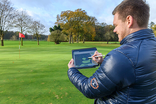
When Andre Budde lifts the robotic mower and other equipment from the car, the areas he's dealing with are a little larger than the garden behind a single-family house. "These are about 90 hectares," says Budde, pointing over the well-kept and vast area of the Emstal Golf Club in Lingen. The first golfers are on the course, and where the row of trees ends, the Ems river flows...
In the midst of this rural-sporting idyll in the Lower Saxony Emsland region, the man with the Husqvarna logo on his jacket is planning the use of professional robotic mowers from the Swedish manufacturer. Andre Budde is one of three product specialists for the Pro Robotics division at the German branch of Husqvarna. PPro Robotics is the team responsible for green space maintenance for professional end customers, partly with impressive robotic mowers for extremely large areas. Before these mowers cut the first blade of grass, comprehensive planning is necessary. An essential tool in this process: miamapo, the intuitive and versatile map editor.
Planning information thanks to the miamapo map
Budde's task is quite challenging. He creates the concept with which several large robotic mowers will maintain the golf course in the future. Where should mowing take place? How large are the areas? How many robotic mowers are needed? Where should the so-called reference stations be set up, allowing the robotic mowers to communicate and determine their exact position? Many of these details are incorporated into the planning, and Budde keeps an overview with miamapo.
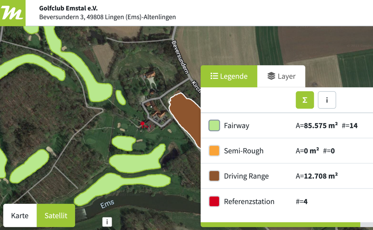
All the necessary planning information is provided by the miamapo map (based on Google Maps). It needs to be fed with data, and this happens easily on-site, for example, using a tablet. No installation is required; work is done after logging into the miamapo account in the browser. "Here, I enter the fairway, for example," explains Budde, circling the area on the satellite image with the digital pen on the tablet. This works just like in drawing programs such as Paint: simply select the corresponding function (in this case, freehand drawing) and start. No navigating through nested submenus, just straightforward work. The same goes for the text tool or for colors and transparencies that can be used for the individual map legend. Additional tools are available for rectangles, polygons, drawing lines, and there are pre-made icons...
Automatic Area Calculation - Important for Communication
Practical: The sizes of the marked areas are immediately calculated, as well as lengths and circumferences. These are precisely the data Budde needs. "That's the advantage of miamapo: I can work with it immediately, have everything I need, and can move quickly with the tool," says Andre Budde. Before Budde and his colleagues in the Pro Robotics department started planning projects with miamapo, they used Google Maps. "But miamapo is more intuitive, more flexible, can be customized individually, and has functions that are important for communication."
Infinite possibilities for individual maps
For example, the ability to import floor plans or drone photos into the miamapo map – because satellite images are not always up to date. Or to share the finished plan as a link (without editing function) to inform customers with the information that is of interest to them. It is also possible to export as a PDF or as a PNG file. Interfaces allow integration of the miamapo map into common business software, such as the geoCapture application. And finally, everything that was drawn and written on the tablet on-site can be easily edited on the computer in the office. At the end of the planning process, the individual miamapo project map is ready.
miamapo makes planning easy
The benefits: Andre Budde is more than satisfied with miamapo. The map editor, thanks to its intuitive operation and tidy interface, makes planning work easier, especially for large projects. miamapo works in the browser (no installation required), provides all necessary drawing tools, allows the import of photos and graphic files, and provides customers with individual maps. Interfaces to common software ensure a smooth workflow. Automated functions (area calculation, distances) are a welcome relief. The conclusion: miamapo is a hole-in-one not only for the golf course project.